Slumgullion Pass and waterfalls. 
How to get there:
Start at the Blue Mesa Reservoir and US 50 junction. Follow SH 149 south for 117 miles to South Fork.
- From US285/C470 to SH149
- 191 miles 4 hours
- GPS
- US 50/US 149
- 38.4895 -107.0589

In General:


- Length: 117 miles
- Driving Time: min. 3 hours
This route heads south from US 50 and follows along the Lake Fork of the Gunnison River into Lake City. It then climbs up and over Spring Creek Pass and shadows the upper reaches of the Rio Grande to its end at the junction with US160 in South Fork.
Photo Ops:


Besides the natural wonders along the route, the heights around Creede and Lake City remain strewn with abandoned mining structures, most of them accessible via rugged backcountry roads.
Alpine Loop – Engineer Pass:


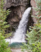 Whitmore Falls
See the Alpine Loop section for more details.
Most passenger vehicles should be able to reach Whitmore Falls.
Head west on 2nd St in Lake City towards Engineer Pass about 11 miles. Park near the sign and take the short, but steep, trail down to the Falls overlook. Beautiful scenery; fishing and camping along Hensen Creek; old mining remnants; this is a road worth exploring!
Alpine Loop – Cinnamon Pass:
See the Alpine Loop section for more details.
Most passenger vehicles should be able to reach the fork beyond Mill Creek CG.
The Cinnamon Pass Rd (CR 30) begins 2.3 miles south of 2nd St in Lake City. Drive past Lake San Cristobal, Castle Lakes CG, the Wager Gulch 4wd road to Carson City, and Mill Creek CG to the Shelf Rd fork at mile 12. Beautiful scenery; fishing and camping; old mining remnants; this is another road worth exploring!
Slumgullion Pass:
At the summit of Slumgullion (11,530 ft), take a hike out along the ridge and catch some of the terrific vistas. The Slumgullion mudslide began some 700 years ago and slumped several miles down the steep mountainside. The earthflow blocked the Lake Fork of the Gunnison River and created Lake San Cristobal, Colorado’s second largest natural lake.
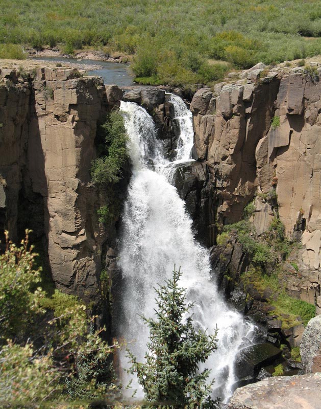
North Clear Creek Falls:
The Falls would be spectacular in any setting, but the fact that the surrounding land is flat and covered with prairie grasses makes its presence here seem extraordinary. Located on a high bench above the Rio Grande, Clear Creek crashes a little more than 100 feet to the canyon below.
South Clear Creek Falls:
- Length: .33 miles RT
- Elev gain: Unknown
- Rating: Easy
- Hiking Time: 15 mins
3.6 miles past the North Falls road, turn into the Silver Thread CG and drive to the far end where you’ll see a small sign saying “falls”. A short walk takes you to a viewing area for the falls.