South rim of the canyon.
- From US285/C470 to Rim Drive Rd
- 244 miles 5 hours
- GPS
- SH 347/Rim Drive Rd
- 38.5405 -107.7010

In General:


Entrance fee is $20 per vehicle
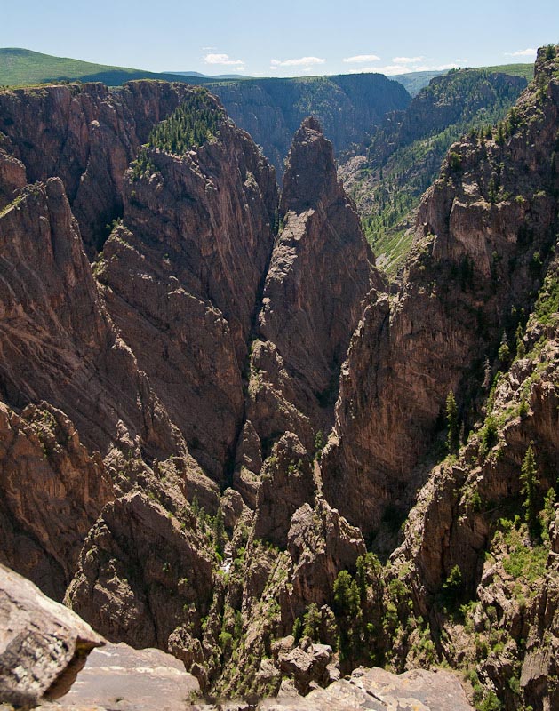
The Black Canyon is so named on account of its steepness. As a result, the canyon walls are most often in shadow, causing the rocky walls to appear black. At its narrowest point the canyon is only 40 ft across at the river and 1100 ft at the rim. The Painted Wall is the highest cliff in Colorado. From river to rim it stands at 2250 feet.
Photo Ops:

South Rim Road Seasonal Closure
The South Rim Drive is 7 miles from Tomichi Point to High Point, and has 12 overlooks. Most are reached by walking a short trail. Allow 2-3 hours to view several overlooks. Those with limited time should consider stopping at Gunnison Point, Chasm View, Painted Wall and Sunset View. The South Rim Visitor Center is located at Gunnison Point.
Rim Rock Nature Trail
Moderate – 1 mile round trip
Trailhead is near the entrance to Campground Loop C and ends at the Tomichi Point Overlook. This self-guided nature trail takes you along a relatively flat path following the rim of the canyon. This trail allows many excellent views of the Gunnison River as well as the sheer walls of the canyon.
Oak Flat Loop Trail
Strenuous – 2 miles round trip
The trail begins near the Visitor Center. Go a short distance to the Oak Flat Loop/River Access sign and follow the trail which leads right. Descend through a grove of aspen to another signed junction. Turn left here to continue on the Oak Flat Loop. The trail meanders through a thicket of oak scrub (Gambel oak) passing near a rock outcrop. The trail then heads west where it begins its ascent to an unmarked overlook offering spectacular views downstream. Pets are not allowed.
Cedar Point Nature Trail
Easy – 2/3 mile round trip
At the end are two overlooks offering breathtaking views of the river over 2,000 feet below. Also visible is the famous Painted Wall, the tallest cliff in Colorado (2,250 ft.), as well as rock islands jutting up from the depths of the canyon.
East Portal Road
Those wishing to drive to the Gunnison River may do so by taking the East Portal Road. This provides access into Curecanti National Recreation Area where camping, picnicking and fishing are available. East Portal Road is closed in winter. The road is extremely steep (16% grades) with hairpin curves. Vehicles with an overall length (including trailer) greater than 22 feet are prohibited.