Great views of the Mount of the Holy Cross.
How to get there:
I-70 west to exit 190 – Vail Pass Rest Area.
Cross the highway and instead of following the pavement to the Rest Area, continue on the dirt road straight ahead.
- From I-70/C470 to CR 16
- 69 miles 1 hr 20 mins
- GPS CR 16 – Shrine Pass Rd
- 39.5296 -106.2179

In General: Seasonal Closure
- Length: 12 miles
- Driving Time: min. 40 mins
In good conditions, this wide dirt road is suitable for any passenger vehicle.
Photo Ops:


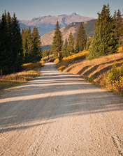
This easy 4wd road leads to some terrific vistas of the Mt of the Holy Cross. Wildflowers and fall foliage can be especially nice. Ends in the charming town of Red Cliff at US 24, on the Top of the Rockies Scenic Byway.![]()
Shrine Mountain Trail
- Length: 4.2 miles RT
- Elev gain: 650 ft
- Rating: Moderate
- Hiking Time: min. 2 hours
The trail begins at the Shrine Pass parking area. It starts in open meadows and reaches a pine forest after about 1.3 miles then climbs to the top of a ridge. In July and August you will be treated to beautiful wildflower displays. The views of Mt Holy Cross off to the southwest, the Gore Range to the north and the Tenmile Range to the east are spectacular.
About a mile from the pass, a short trail from a parking area with restrooms leads to an overlook with a fine vista of the Mt of the Holy Cross.