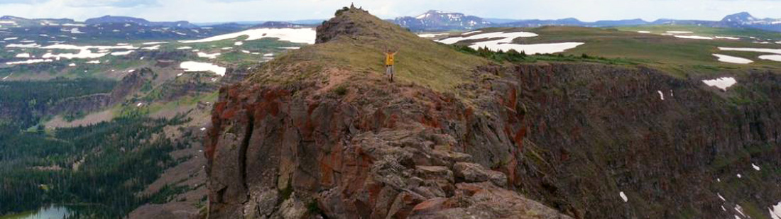
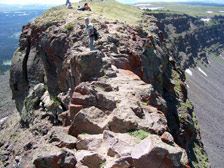
Three feet wide and 800 down!
How to get there:
From CR17/Main St in Yampa, head south on Main (CR7) 7 miles to FR900, then anther 10 miles to the Stillwater Trailhead.
- From CR17 to TH
- 17 miles 1 hr 10 mins
- GPS
- TH Parking
- 40.0276 -107.1233

In General:


- Length: 5.6 miles RT
- Elev gain: 1600 ft
- Rating: Moderate/Difficult
- Hiking Time: min. 3 hrs
The Devil’s Causeway follows a narrow strip of land that connects two major sections of the Flat Tops. Both sides of the trail are 60′-80′ cliffs with steep talus slopes dropping another 600′-800′ into the drainage below. The rough, 3′ wide crest is a spot any hiker or climber will never forget.
The trail parallels the north side of Stillwater Reservoir for 0.8 miles, reaching a registration/information board at the junction with trail #1120. Head right (N) at the junction and pass Little Causeway Lake at mile 1.6; good camping and fishing at the Lake. From here the trail climbs along and through talus slopes to a watershed divide at mile 2.3. A side trail on the left makes a steep ascent to the Devil’s Causeway, mile 2.8.
Photo Ops:

On the way to Stillwater TH:
Mile 7 to Mile 17 – Bear River Designated Dispersed Camping
Whether you are looking for solitude or group capability, open air vistas or sun dappled forest, with 32 individual campsites available, there is a dispersed camping site for everyone. Some sites are in close proximity to trailheads or fishing areas and some take you off the beaten path. Sites are marked with numbered camping posts.
All the dispersed campsites have Forest Service fire grates which must be used for campfires and most of the sites feature picnic tables, except for the grouped sites where self-contained RVs often camp. Prepare for rustic camping. Drinking water and toilets are available a few miles away at Bear Lake, Horseshoe and Coldsprings campgrounds. Toilet facilities are also located at dispersed sites #3-4 and #9-10.
Mile 12 – Yamcolo Reservoir 
A boat ramp provides access to the Yamcolo Reservoir for non-motorized and motorized boats. Ramp becomes unuseable in late summer.
Mile 13.8 – Bear Lake CG and Picnic Area 
Bear Lake Campground was newly reconstructed in 2002-2003, but has retained its rustic nature with most of the 43 sites naturally screened from one another. This area accesses some great fishing and hiking. Surrounded by the 235,000-acre Flat Tops Wilderness, the views are spectacular.
Mile 16.5 – Horseshoe Campground
This is a small, quiet campground. The 7 campsites have fire rings and are dispersed among the trees, lending a feeling of privacy. This area accesses some great fishing and hiking; Smith Lake TH is nearby.
Mile 17 – Location
This is a small, very popular campground. There are 5 campsites with fire rings. It is an open campground with a small waterfall and a pond. With 11,000′ to 12,000′ mountains as a backdrop, the views are spectacular.
Mile 17.3 – Stillwater TH
This trailhead serves three trails leading into the Flat Tops Wilderness as well as fishing access at Stillwater Reservoir. A vault toilet is available.