Awesome fall colors.
How to get there:
Starts from the Kebler Pass Rd about 7 miles west of Crested Butte and connects with SH 135 two miles north of Gunnison.
- From Denver to Crested Butte
- 217 miles 4 hr 30 mins
- GPS
- Kebler Pass Rd/CR730
- 38.8527 -107.0976

In General:


- Length: 23 miles
- Driving Time: min. 1 hour 20 mins
This road winds its way up to Ohio Pass at an elevation of 10,074′ in two miles. This first section may not be passable to 2wd vehicles depending on conditions. As you drop down from the pass, it will travel through a large aspen forest before emerging into hay meadow bottoms and cattle ranches along Ohio Creek.
Photo Ops:


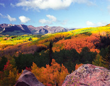
Terrific vistas! The scenery is spectacular. Rugged peaks, the Anthracite Range with the Castles; and in a good year, unrivalled fall colors.
Fishermen!
Mile 4.8 – Watch for a Forest Service sign on the right marked “Beaver Ponds.” A short walk puts you on a large, deep beaver pond full of trout. There are three or four more good sized ponds just west.
Mill Creek Rd.
Mile 14.4 – CR 727 Access the National Forest and the West Elk Wilderness. The views of the Castles and Baldy Mountains are inspiring. Mill Creek is a medium small creek that yields nice brook and rainbow trout.