Ouray to Durango 


How to get there:
Starts at 6th St in Ouray and heads south to Durango.
- From Denver to Ouray
- 283 miles 5 hr 40 mins
- GPS
- US-550/6th St
- 38.0230 -107.6714

In General:


- Length: 71 miles
- Driving Time: min. 1 hr 30 mins
The Million Dollar Highway is the portion of the Skyway from Ouray over Red Mountain Pass to Silverton. The Skyway continues over Molas Pass then Coal Bank Pass and this section ends at US 160 in Durango. See the Telluride > SH 145 section to complete the loop.
Photo Ops:
Mile 0.6 – Yankee Boy Basin Rd 


The start of the Yankee Boy Basin route. See its tab for more details.
Mile 1.3 – Amphitheater CG Rd 


Drive up the road towards the campground for great vistas of the town of Ouray spread out below the mountains above it. Baby Bathtubs and the Portland Trail TH’s.
Mile 13.3 – Brooklyn Rd N
The northern terminus of the Brooklyn Rd route. See its tab for more details.
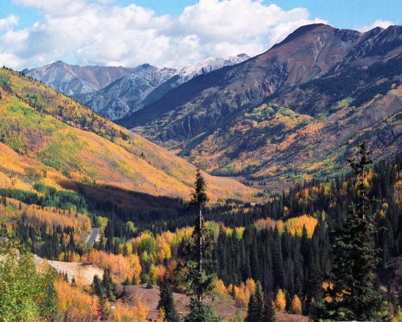
This section of the Million Dollar Hwy traveling along the gulch and the Uncompahgre River up to Red Mountain Pass is simply spectacular! Fall foliage can be impressive and I have seen Rocky Mountain goats on the cliffs along the highway. The Yankee Girl Headframe stands tall in the Red Mountain Mining District at mile 11.3 with some great vistas north into the gorge nearby.
Mile 17.4 – Brooklyn Rd S
The southern terminus of the Brooklyn Rd route. See its tab for more details.
Mile 18.2 – Ophir Pass Rd
Try the 4 mile, easy drive to the top of the pass for some spectacular vistas. See its tab for more details.
Mile 21.0 – South Mineral CG/Ice Lake Basin Trail
4 miles west on CR7, a 2wd road to the campground and 4wd beyond. The trail, strenuous and steep, leads up above timberline to high alpine lakes surrounded by meadows of wildflowers and rocky peaks.
Mile 23.0 – Silverton
This active mining town is also the northern terminus of the Durango & Silverton Narrow Gauge Railroad and the southern gateway to Animas Forks ghost town and the Alpine Loop Backcountry Byway. See the Alpine Loop section for more details. The town is a National Historic District and still has the feel of the mining era. Silverton’s business section was built in the late 1800s and unlike many other mining towns, never experienced a major fire. The “other side” of town was centered on Blair Street. At one time, this notorious street was home to forty saloons and brothels and nearly half of these buildings are still standing today.
Mile 29.4 – Molas Pass 
10,899 ft. The area has many lakes and hiking trails to be explored; one can even walk part of the 470+miles Colorado Trail that crosses over Molas Pass on its way to Denver. Little Molas Lake CG is about 1 mile west of US-550 on Molas Pass just north of and on the other side of the Molas Overlook. This lake is particularly scenic.
Mile 71 – Durango 
From Molas Pass the fantastic vistas continue as the road reaches Coal Bank Pass at 10,660 ft and begins to drop into the Animas valley passing Durango Mtn Resort. There are spectacular views of Pigeon and Turret Mountains that rise to 13,000 feet, and three fourteeners; Windom, Eolus, and Sunlight. The highway then parallels the Animas River (Early explorers named it El Rio de las Animas Perdidas, River of Lost Souls.) to the junction with US160 in Durango.
The Durango & Silverton Narrow Gauge Railroad offers a view of Colorado’s mountain wilderness between Durango and Cascade Canyon inaccessible by highway.