An early start is recommended.
How to get there:
Parking area on east side of SH 7 about 9 miles south of Estes Park.
- From I-25/I-70 to parking
- 65 miles 1 hr 25 mins
- GPS
- Parking Area
- 40.2720 -105.5421

In General:

The trail to Chasm Lake is consistently steep and easy to follow. Snow coverage is possible year round, but well placed cairns will keep you on track. Be prepared and start early to ensure that you are back below treeline before the typical afternoon thunderstorms arrive.
Photo Ops:


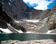
Chasm Lake sits in a deep cirque surrounded by Mt Meeker, Longs Peak and Mount Lady Washington. Longs Peak’s Diamond face rises 2,500 ft above this awe inspiring lake. Watch for marmot, pika, ptarmigan, elk and wildflowers along the way. The vistas are amazing.
Chasm Lake Trail
- Length: 8.4 miles RT
- Elev gain: 2,456 ft
- Rating: 13.3 Mod./Strenuous
- Hiking Time: min. 4 hours
The trail travels through an evergreen forest, crosses the top of an unnamed cascade and reaches treeline in 1.85 miles and the Battle Mountain Backcountry Campsite spur at 2.45 miles then turns toward the Longs Peak diamond. It reaches the Chasm Lake/East Longs Peak Trail junction at 3.25 miles then bears southwest and gradually rises up the west side of a glacier-carved gorge at the base of Longs Peak, at the top of which lies Chasm Lake. The trail passes a view of Peacock Pool far below you then drops down to a bench that separates upper and lower Columbine Falls at 3.8 miles. The trail crosses the valley and reaches a patrol cabin and toilet at 4.0 miles. From here it’s a steep, 0.2 mile, scramble up the rocks to Chasm Lake.