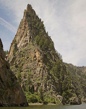
A series of three reservoirs. 
In General:


Curecanti includes Blue Mesa, Morrow Point and Crystal Reservoirs. The recreation area is surrounded by Bureau of Land Management and U.S. Forest Service land.
Photo Ops:
Morrow Point Overlook

20 miles south of Crawford. A short trail leads from the roadside to an incredible view of the Black Canyon.
Pioneer Point Picnic Area
16 miles east of the overlook, this area has facilities for large and small group picnics. The area also provides a stunning overlook of the Black Canyon.
Soap Creek Rd


4.4 miles east of the picnic area turn onto Soap Creek Road and continue for seven miles up the Soap Creek Arm to Ponderosa campground. Continue for another 2 miles to the Soap Creek Campground and several trailheads.
Morrow Point Boat Tours

About a mile west of SH 92/US 50. Join a park ranger for a leisurely 1½ hour boat tour on the Morrow Point Reservoir into the Black Canyon of the Gunnison. Tours run twice a day at 10:00 am and 12:30 pm everyday except Tuesday. Tours begin around the beginning of June and end after Labor Day. $16.00 – Adults $8.00 – All Children 12 and under.
Tours begin at the Pine Creek boat dock, accessed from the Pine Creek Trail at US Highway 50, milepost 130 (35 miles east of Montrose and 25 miles west of Gunnison).
Dillon Pinnacles


5.3 miles east of SH 92/US 50 just north of the middle bridge. This moderately strenuous trail ascends 600 ft. in a distance of two miles. Offers spectacular views of Blue Mesa Reservoir, the distant San Juan Mountain peaks, and the weirdly eroded volcanic Dillon Pinnacles.
Red Creek Rd

1.5 miles past the Pinnacles. The road accesses a campground then follows Red Creek, with its many beaver dams and ponds, north into the Sapinero Wildlife Area and eventually the Gunnison National Forest.
Rainbow Lake Rd

A little over a mile east of the Elk Creek Visitors Center on Highway 50, Rainbow Lake Road takes you into BLM and USFS land; beyond is Rainbow Lake and the West Elk Wilderness area.
